Origins and Development
Transfers of water between surface water, snow/ice, precipitation, and atmospheric water vapour, and of energy between the atmosphere and soil, snow and vegetation, are both major components of hydrological and atmospheric processes. Scientific understanding of these linkages has improved markedly over the past few decades, but until recently, hydrological and atmospheric models operated in mutual isolation, and the interactions between them were not well represented. The decade to 2010 has seen an intensification of research around the world to establish connections between atmospheric and hydrological models, with the aim of improving both flow simulations and predictions of climate and weather.
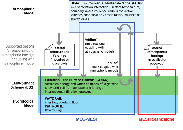
The process began by linking land-surface and atmospheric models, through the development of Land Surface Schemes (LSS), which have become increasingly sophisticated; the Canadian LSS, CLASS, is a particularly good example. More recently, LSS models have been incorporated into hydrological models, to provide stand-alone Hydrology-Land-Surface Scheme (HLSS) systems. The next step has been to link atmospheric and hydrological models: when an HLSS is incorporated into an atmospheric model, the result is a fully-coupled system. However, most of these efforts have led only to the development of modelling tools suited to the needs of researches; the use of these architectures in operational hydrometeorological forecasting systems has been limited.
To overcome this obstacle, the Numerical Weather Prediction Research Group at Environment and Climate Change Canada developed the Modélisation
Scientists at Environment and Climate Change Canada's National Hydrological Research Centre and the Centre for Hydrology have used MEC as the foundation for a coupled land-surface and hydrological model known as MEC-Surface & Hydrology, or MESH. This was originally developed from the University of Waterloo's WATCLASS, which linked CLASS with an existing hydrological model geared towards flood-forecasting, WATFLOOD.
The system has been implemented both as an HLSS, integrating CLASS and hydrological modelling components, with atmospheric
More detailed information is also available in the following paper:
| Pietroniro A., Fortin V., Kouwen N., Neal C., Turcotte R., Davison B., Verseghy D., Soulis E. D., Caldwell R., Evora N., and Pellerin P. (2007). Development of the MESH modelling system for hydrological ensemble forecasting of the Laurentian Great Lakes at the regional scale. Hydrol. Earth Syst. Sci., 11: pp 1279-1294. (PDF) |
Benefits and Advantages
Two important advantages of the MESH system are that
- It is an 'open' community system
- It is part of an operational forecasting system in use with Environment and Climate Change Canada
This not only means that researchers and end-users may use and modify it freely, but also that MESH will continue to improve over the years, benefitting from improvements made to the modelling system for both research-related and operational purposes.
The development of MESH ties directly into a series of existing projects and programs in Canada, including
- The Drought Research Initiative (DRI)
- The National Agri-Environmental Standards Initiative (NAESI)
- The International Polar Year (IPY)
- The network for Improved Processes, Parameterization and Prediction in cold-regions hydrology (IP3)
- The Changing Cold Regions Network (CCRN)
- The Global Water Futures program (GWF)
The system permits several different surface models to coexist within the same modelling framework, enabling
- a simple force-restore scheme
- a version of the Soil-Vegetation-Snow (SVS) LSS
- the Canadian Land Surface Scheme (CLASS)
One of the primary goals set for MESH is to improve the description and quantification of the importance of sub-grid variability; to achieve this, CLASS may be configured to run on a number of different HRUs or tiles within each
How to obtain MESH
Environment and Climate Change Canada's Hydrometeorology and Arctic Laboratory, with support from IP3, IPY, and DRI, has produced a stand-alone version of the MESH system, which reads atmospheric forcings from files rather than requiring the atmospheric model to be run concurrently: it is available for download here.
If you have any enquiries relating to MESH, please contact MESH@ec.gc.ca - managed by Environment and Climate Change Canada's National Hydrological Research Centre in Saskatoon. Further information is available on the MESH wiki.
Events and Training
If you would like to receive details of forthcoming MESH events and training courses, please contact MESH@ec.gc.ca.
- Workshop / Training Course Agendas and additional information
- Presentations from the Workshop